
Conquer the Abbott Ridge Trail: Your Ultimate 2026 Day Hike


The Abbott Ridge Trail is not only one of the best hikes in Glacier National Park, it’s one of the best day hikes we’ve ever done, full stop. Yes, it’s that good.
This epic day hike has beautiful ancient rainforest, out-of-this-world mountain views and a fun ridge scramble to boot. If you’re looking for bang for your buck, you can’t get better than this.
If you only do one hike in Glacier National Park, choose the Abbott Ridge Trail.
Got your attention? Good!
Read on for our complete guide to the Abbott Ridge Trail, so you can get out there and enjoy this beautiful hike in Glacier National Park for yourself.
Canada Travel Resources
- Getting there: search for flights to Canada
- Where to stay: search for guesthouses and hotels
- How to get around: rent a car to get around Canada
- Travel insurance: get travel insurance for your trip
- Money: get a Wise money card to save money in Canada
Abbott Ridge Trail Overview
- Location: Glacier National Park, Canada
- Length: 14 – 17 km (depending on options)
- Elevation: +1050 to +1300m (depending on options)
- Time: 6 – 7 hours
- Season: Summer (July to September)
- Gateway city: Revelstoke
- Type: There-and-back
- Difficulty: Hard
- What to expect: Epic mountain views, tons of glaciers and a walk on a stunning ridge
Abbott Ridge Trail Location
The Abbott Ridge Trail is located in stunning Glacier National Park in Canada, which is almost exactly halfway between the mountain towns of Golden and Revelstoke (i.e., around 2.5 hours west of Banff).
It’s also located almost exactly halfway between Vancouver and Calgary on the Trans-Canada Highway.
Like almost all the hikes in Glacier National Park, the Abbott Ridge Trail starts from the Illecillewaet Campground.
Heading to Jasper? Check out 14 Awesome FREE Things to Do In Jasper
Glacier National Park (The Canadian One)
Glacier National Park is one of Canada’s least-known national parks and a real hidden gem! Often described as “fifty Switzerlands in one”, this small park has big appeal for hikers and mountaineers worldwide.
It was established in 1885 following the completion of the transcontinental railway and has a long and fascinating history with early mountaineers who came to climb the rugged peaks in the park.
For another great hike in Glacier, check out Hermit Meadows
The hiking trails in Glacier National Park were made for these mountaineers to ascend to high base camps quickly, so they could get on with the business of peak-bagging.
This is why the hikes in Glacier National Park are notoriously STEEP! It also means you’re following in the footsteps of these early mountaineers, which is so cool.

Interested in more epic hikes? Check out The Ak Suu Traverse in Kyrgyzstan
Contrary to popular belief, the mountains in the park aren’t part of the Rockies, but the older Columbia Mountains.
We absolutely love Glacier and it’s tied with Yoho as our favourite national park in Canada. It has so much to offer for world-class hiking.
Yes, all the trails are famously super steep, but they’re also equally stunning (and not that crowded), which makes it one of the best places for hiking in all of BC!
Good to Know: Glacier National Park is on Pacific Standard Time, one hour behind Mountain Standard Time (the time zone Banff and Calgary are in).
Glacier National Park Entrance Fee
As Glacier National Park is a Canadian national park, you need a park pass to hike in the park.
Entrance is currently $11 CAD per person per day.
If you plan on visiting multiple parks in Canada, or will stay more than a week within any national park, then you can purchase a Discovery Pass. This costs $151.25 CAD for an entire car and is valid for a year. It’s a pretty good deal!
Related: 13 Unique and Fun Things to Do In Parksville
How Difficult is the Abbott Ridge Trail?
We won’t mince words here – the Abbott Ridge Trail is hard. It’s a strenuous trail that gains a hell of a lot of elevation in a short amount of time, but it’s worth it. Oh, is it ever worth it.
That said, almost anyone who is pretty fit and able should be able to make it to the ridge itself (the official end of the trail).

If you’d like to scramble up to Abbott Ridge Summit, you need to be experienced and confident (more on that below).
This is a good time to remind you about travel insurance! If something goes wrong, you want to be covered. We use and recommend SafetyWing. Trust us, we’ve used a lot of travel insurance and they really are the best.
What to Expect on the Abbott Ridge Trail
The Abbott Ridge Trail is a pretty comprehensive day hike, so be prepared for a full day out. That means bringing layers, a rain jacket and enough food and water to last you for the entire day.
There is pretty much no water on the entire trail, so bring lots to cover you for a full-day hike (you’ll want quite a bit).
Due to the steep gradient, hiking poles are a very good idea. The trail is well-signposted, so offline maps aren’t essential.
Of course, if you like to track your stats or just have the comfort of an offline map, AllTrails is the way to go – and it has a good map of the Abbott Ridge Trail. Just be sure to have the pro version so you can download it in advance, as there is no reception up there!
Here’s what we usually bring on our day hikes:
Bear Safety on the Abbott Ridge Trail
This is hella important, so please read: Glacier National Park is big-time bear country. BIG-TIME.
It has some of the most frequent grizzly sightings of any park in Canada and trails are often closed or have restrictions on them due to enhanced bear activity.
In fact, when we were there, the entire Illecillewat Valley was closed due to the high grizzly presence.

This doesn’t mean you have to be terrified, but it does mean you have to be prepared. ALWAYS carry bear spray with you (and know how to use it). Carry it where you have access to it quickly and not deep inside your pack.
If you don’t want to purchase a can, you can rent one from the Registration Hut at Illecillewaet Campground for $15 CAD/day.
Abbott Ridge Trail Options
While the Abbott Ridge Trail is essentially a there-and-back trail, there are a few variations you can make.
Firstly, there is a “shorter route” and a “longer route”. After around 3 km, the trail splits, with a sign indicating the directions each option heads in.
The most popular option (and what we did) is to take the shorter way up and the longer route down. Although you have to work hard, this gets you past the treeline quicker and then you have longer, beautiful views on the way down.
I really loved this option, whereas Zandy was on the fence about it. Taking the longer way down adds around 2 km of extra distance to the overall hike, but I think the views were very worthwhile. It really depends on how much juice is in your legs at the end of the day!

The other variation you can do is to explore the ridge and/or climb the summit.
The Abbott Ridge Trail officially ends at the start of the ridge (hence the name). From the trailhead to this point is 6.5 km and 1050m of elevation gain.
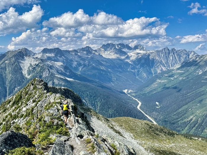
However, you can continue along the ridge and take in the great views of the Illecillewaet Glacier, Asulkan Valley and much more. The ridge itself is a relatively easy scramble, but still requires a lot of care and attention as the path is rocky and uneven and there are some very, very steep drops!
You can walk along the ridge for around 30 – 45 minutes. If you have a fear of heights, have small children, or are inexperienced, then perhaps skip this option.
And finally, if you are experienced and confident, you can go even further, to the Abbott Ridge Summit.
We were at the end of the ridge and were contemplating whether the effort would equal the reward and we are so glad we decided to make a go for it! The views are unparalleled and it’s very, very worthwhile.
It’s about an extra 30 minutes from the end of the ridge to do the scramble up the summit and there are multiple routes up. It definitely looks harder than it is.
If you go this route, it adds an extra 3 km return (1.5 km one-way) and 200m of elevation gain from the end of the official trail.
This option, however, is only for those quite experienced and confident because it can get quite dicey. But, if you’re experienced and want to add a bit more zest to your day, we highly recommend it!

Abbott Ridge Trail Description
Like the vast majority of the hikes in Glacier National Park, the Abbott Ridge Trail begins near the Illecillewaet Campground. It first passes by the ruins of the Glacier House, an old hotel that operated from 1887 – 1925 and attracted guests from all over the world.
Just after you pass the Glacier House ruins, you turn onto the Abbott Ridge Trail.
Unlike the Glacier Crest Trail, as soon as you turn onto the Abbott Ridge Trail, it begins to climb immediately! Brace yourself for a ton of switchbacks.

The trail begins in a beautiful ancient rainforest. For about 2 km, it’s pretty much all steep switchbacks until you reach Lake Marion (425m higher than the start of the trailhead). This is a good spot for your first break!
Just past Marion Lake is the junction for the shorter route or longer route (see above). If you take the shorter route, you hit the treeline not far after.
After you hit the treeline, it’s another 20-30 minutes until you reach the hut. This is when the views start to get really outstanding (and they only just get better and better).
The hut on the Abbott Ridge Trail is used by Parks Canada staff for avalanche control in the winter season. It’s not open to the public (unlike the nearby Asulkan Hut).
Important: if you’re short on time and you aren’t able to make it all the way to the ridge, you still get epic views from the hut. If you’re time-constrained, this is a good turn-around point.
From the hut, you can see the ridge in front of you – it’s like a rock wall or a big, high pile of stones – and you can see exactly where you’re going.
As you ascend the ridge, you loop around to the other side of the mountain – and then you get awesome views of the other side! It’s unreal.
It’s not at all scrambly until you reach the edge of the official trail. If you’re planning on doing some ridge walking or making a summit push, this marks a good spot to stash your hiking poles. Just remember to drop a pin so you can find them after (don’t be like us and spend 15 minutes searching for your poles!).
On the ridge are multiple good rocks to enjoy lunch with a million-dollar view.

Where to Stay Nearby
For excellent camping near the Abbott Ridge Trail, there is the Illecillewaet Campground in Glacier National Park.
We love Illecillewaet! It’s a great campground, with big, beautiful spots and is conveniently located next to the trailhead for most of the major trails in the park. It costs $23 CAD/night and is first-come, first-serve.
If you’re looking for more amenities, we recommend basing yourself in Revelstoke. It’s an adorable mountain town with great lodging and food options.
Basecamp Resorts Revelstoke and the Alpenrose Bed and Breakfast are our top picks for accommodation in Revie (as the locals call it).
Disclaimer: This post may contain affiliate links. If you buy or book anything through them, we’ll earn a small commission at no extra cost to you. Thank you for supporting this website!
